Every flight instrument and app (XCTrack, Skytraxx, Flymaster, Flyskyhy…) records your flight as an IGC file. What you can do with it depends on the tool you open it in: some show a simple 2D track, others replay the flight in 3D over real terrain, help you understand your climbs or turn it into a video.
We build XCviewer, so we are not neutral. We have tried to be fair: the table only lists features we could verify on each tool’s website, and each comparison says when another tool is the better choice.
At a glance
| Feature | XCviewer | SkyViz | flyXC | SeeYou | Google Earth |
|---|---|---|---|---|---|
| Works in the browser | YesWeb app, also on phones and tablets | Yes | Yes | YesSeeYou Cloud, plus Windows and mobile apps | PartlyThe web version opens KML files; Google Earth Pro is a desktop app |
| 3D replay of IGC files | YesFree | Paid planPro; the first 3D replay is free | YesFree | Paid plan | PartlyAfter converting the IGC file to KML or KMZ |
| Flight analysis (graphs, climbs, glides) | YesGraphs on the free plan; KK7 thermals and advanced colors in Pro | PartlyLogbook statistics and trends, live metrics during replay | PartlyAltitude chart along the track | Paid planDetailed statistics, comparison with other pilots | Not listed |
| Several flights replayed together | Paid planUp to 10 flights in sync | Paid planMulti-track 3D replay | YesSeveral tracks on the same map | Paid plan | PartlyBy loading several KML files |
| Video export | Paid planAutomatic camera styles and a video Studio | Paid planAutomatic cinematic camera, 9:16 and 16:9 MP4 | Not listed | Not listed | PartlyManual, with Movie Maker in Google Earth Pro |
| Flight logbook | Partly2 saved flights free, unlimited in Pro | YesFree and unlimited, XContest import | Not listed | Paid plan | Not listed |
| XC route planner | Paid planFAI triangles, XContest-style scoring, wind-aware glide | Not listed | YesFree, with distance and XC score | Paid planTask planning, designed for gliding | Not listed |
| Airspace | Paid planAirspace map and 3D route analysis | Not listed | YesOn the map and in 3D (ground footprint) | Paid planIncluding warnings in SeeYou Navigator | Not listed |
| Paragliding weather | YesForecast free; flyability score, wind layers, stations and webcams in Pro | Not listed | PartlySoundings through the flyXC plugin for Windy | PartlyTopMeteo and SkySight integrations (separate subscriptions) | Not listed |
| Live tracking | Not listed | Not listed | YesInReach, Spot, XCTrack via XContest, FlyMaster, OGN and more | PartlyLive OGN traffic in SeeYou Navigator | Not listed |
| Price | Free plan, Pro subscription (monthly or yearly) | Free Basic plan; Pro €4.90/month billed yearly | Free and open source, funded by donations | Subscription about €49/year excl. VAT, free trial | Free |
“Paid plan” means the feature needs a subscription. “Not listed” means we could not find the feature on the tool’s website.
Information checked on October 7, 2026 from each tool’s public website. Features and prices change: if something is out of date, write to us and we will correct it.
SkyViz, flyXC, SeeYou, Google Earth, Ayvri, Doarama, XContest, XCTrack and the other names mentioned are trademarks of their respective owners. XCviewer is not affiliated with them.
XCviewer in action
Real screens from XCviewer. Each one links to a step-by-step tutorial.
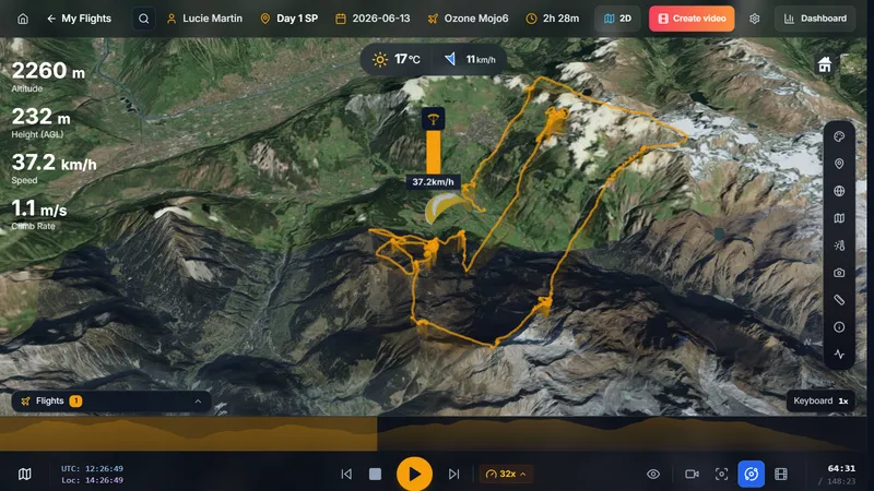
3D replay of an IGC flight on real terrain, right in the browser
See the tutorial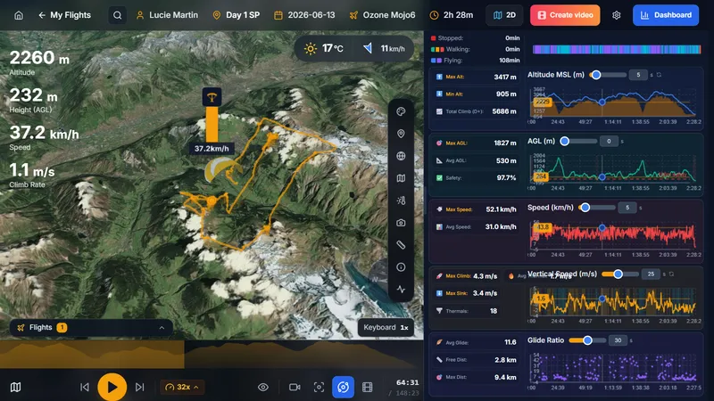
Dashboard with altitude, speed, climb rate and glide ratio charts linked to the 3D view
See the tutorial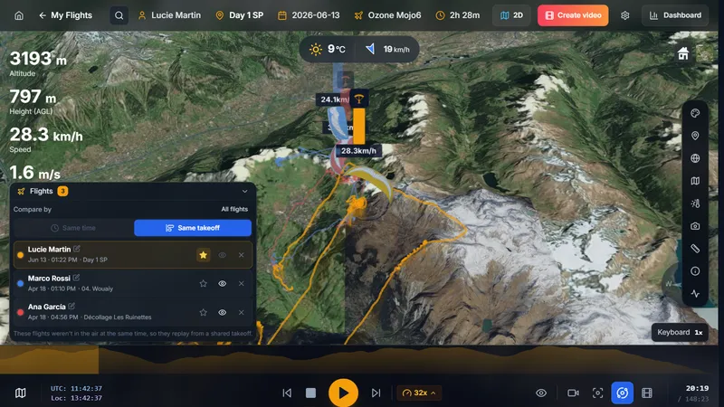
Three flights replayed together from the same takeoff to compare lines and climbs
See the tutorial
Which tool for which pilot?
XCviewer
Pilots who want 3D replay, detailed analysis, XC planning, weather and video in one place.
SkyViz
Pilots who mainly want a free logbook and polished 3D videos for social media.
flyXC
Pilots who want a free, open-source map to plan routes and follow friends live.
SeeYou
Pilots, especially sailplane pilots, who want a complete planning, navigation and analysis suite on desktop and mobile.
Google Earth
Pilots who do not mind converting files and want to explore a track in Google Earth for free.
Other tools worth knowing
replay.flights
A personal project for quick 3D replays of IGC files in the browser, with shareable scenes and a thermal view. Requires a Google sign-in.
Burnair 3D IGC Viewer
Burnair’s free drag-and-drop 3D IGC viewer, from the Swiss team behind the Burnair app and map.
XCFinder
Search and replay in 3D the French league (CFD) flights of 50 km and more since 2004, and turn a flight into a route for XCTrack or SeeYou.
XContest
The reference for online XC leagues and scoring. Its flight pages focus on the map and the score; download the IGC file to replay it in 3D elsewhere.
Ayvri (Doarama)
ClosedAyvri (formerly Doarama) was a popular 3D replay site. Its consumer service closed at the end of 2022, and scenes could not be exported.
Detailed comparisons and guides
- XCviewer vs SkyViz: which 3D IGC viewer should you choose?
- XCviewer vs flyXC: two online paragliding tools compared
- XCviewer vs SeeYou: paragliding flight analysis compared
- IGC files in Google Earth vs a dedicated 3D IGC viewer
- Ayvri alternative: where to replay your paragliding flights in 3D
- How to open an IGC file (computer, Mac or phone)
Frequently asked questions
What is the best free IGC viewer?
It depends on what you need. For a free 3D replay with graphs, XCviewer and flyXC both work in the browser without paying. flyXC is completely free and great for planning and live tracking; XCviewer goes further on flight analysis and video. SkyViz’s free plan is mainly a logbook, with 3D in its Pro plan.
Can I open an IGC file on my phone?
Yes. Web-based viewers such as XCviewer, SkyViz and flyXC work on a phone. You just need to find the file: XCTrack keeps it in its Tracklogs folder, and if you upload your flights to XContest you can download them from there.
Can Google Earth open IGC files?
In most cases, not directly. You first convert the IGC file to KML or KMZ (XContest and tools such as igc2kmz can do it), then open it in Google Earth. Dedicated viewers skip that step and add flight data such as the climb rate and thermals.
What replaced Ayvri and Doarama?
After Ayvri closed its consumer service in 2022, pilots moved to tools such as XCviewer, SkyViz, replay.flights and flyXC. Since Ayvri never allowed exports, you need the original IGC files, from your instrument or from XContest.