The All-in-One
Paragliding Platform
Plan Smarter. Fly Better. Progress Faster.
One Platform for the Full Pilot Journey
From logbook and 3D analysis to route planning, weather intelligence, airspace awareness, and school training workflows.
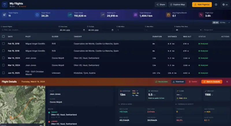
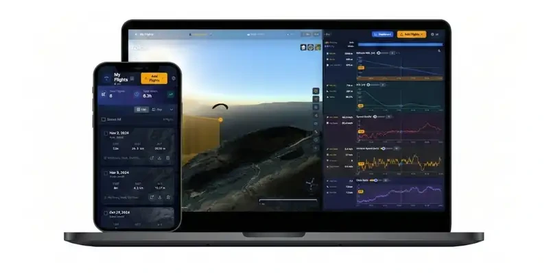
Logbook & Flight History
Import IGC flights, organize your history, and keep your flying progression in one place.
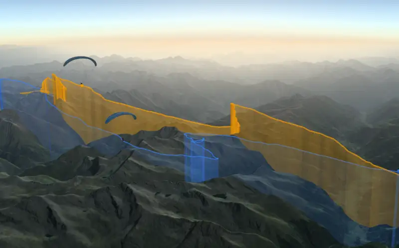
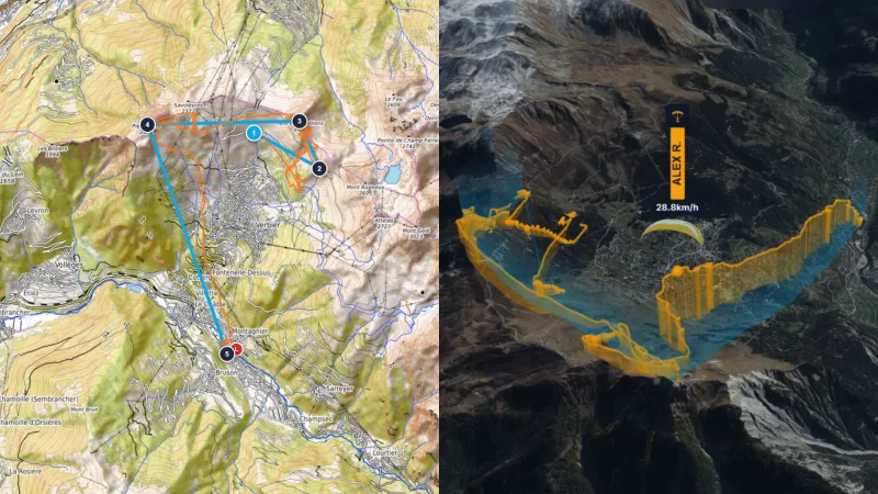
Route Planning & 3D Preparation
Design routes and FAI tasks, visualize terrain in 2D/3D, and prepare decisions before takeoff.
Weather & Airspace Intelligence
Use forecasts, weather stations, webcams, and airspace overlays to evaluate flyability and risk.
School & Formation Workspace
Manage students, events, subscriptions, and educational follow-up in a dedicated school dashboard.
Signature Tools
Tailored for Demanding Pilots
Showcase the capabilities that make XCviewer the preferred companion for training, competition preparation, and cinematic storytelling.
FEATURE 01
Flight Comparison in Sync
Replay multiple pilots side-by-side to compare tactics, match thermals, and learn from every glide.
FEATURE 02
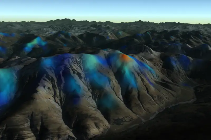
Thermal Overlay by KK7
Layer KK7 thermal hotspots over your route to understand convection strength and plan efficient climbs.
FEATURE 03
Smart Flight Collection
Organize your flights in a personal collection, relive your adventures, and share interactive replays seamlessly with friends.
FEATURE 04
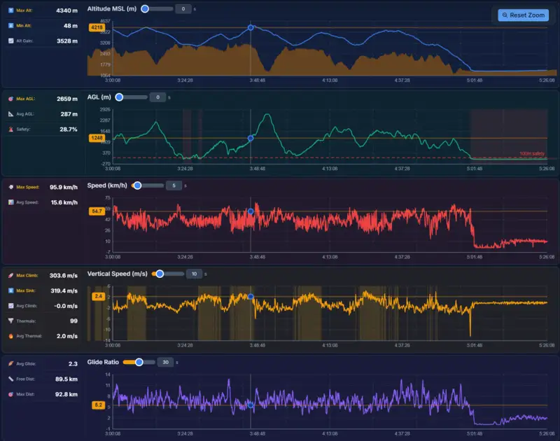
Detailed Graph Analysis
Link altitude, vario, wind, and energy graphs with precise timeline scrubbing for data-driven insights.
FEATURE 05
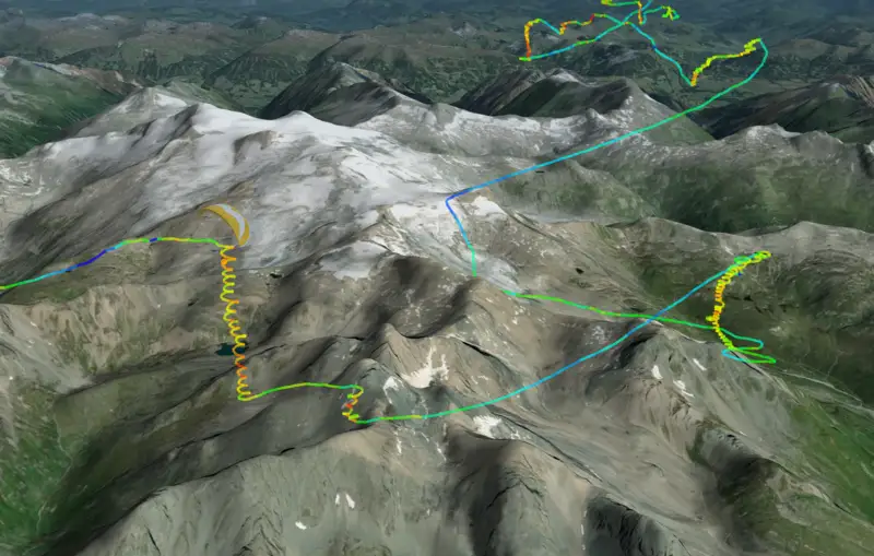
Path Colorization
Color-code your track by altitude, climb rate, speed, or glide to surface the story behind every line.

FEATURE 06
Sun Synchronization
Lock the scene lighting to the real sun position to preview shadows, golden hour, and launch conditions.
FEATURE 07
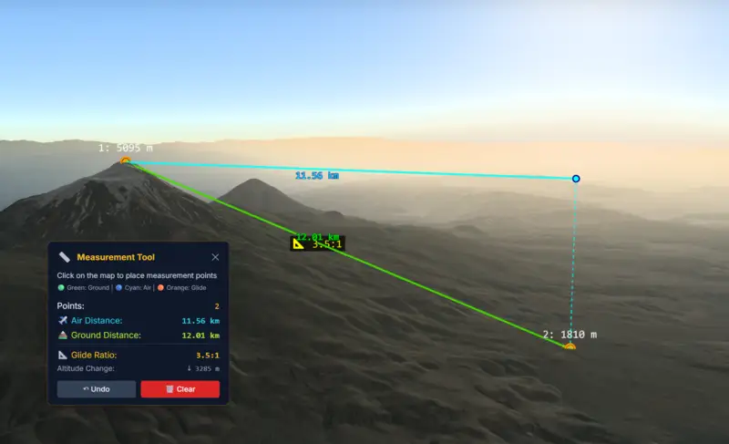
Measuring Tool
Drop interactive markers, measure glide ratios, and verify terrain clearance directly inside the 3D view.
FEATURE 08
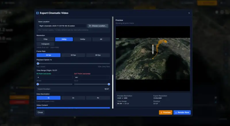
Cinematic Video Export
Generate broadcast-quality 4K videos of your flights with smooth camera transitions, ready for social media sharing.
FEATURE 09
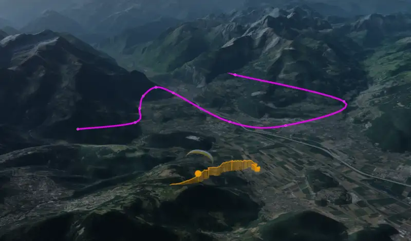
Custom Camera Path Editor
Design your own cinematic shots with full control over keyframes, easing, and camera angles for professional storytelling.
FEATURE 10
Mobile App Compatibility
Analyze and visualize your flights on the go with full mobile support. Access your flight collection, replay flights, and view detailed analytics from anywhere.

FEATURE 11
School Formation Management
Complete management platform for flight schools. Manage students, organize training events, track progress, handle subscriptions, and build an engaged learning community with automatic email notifications and interactive features.
FEATURE 12
Route Planner & FAI Triangles
Plan routes and reusable FAI triangles, then visualize them in 3D with terrain-following walls for realistic task preparation.
FEATURE 13
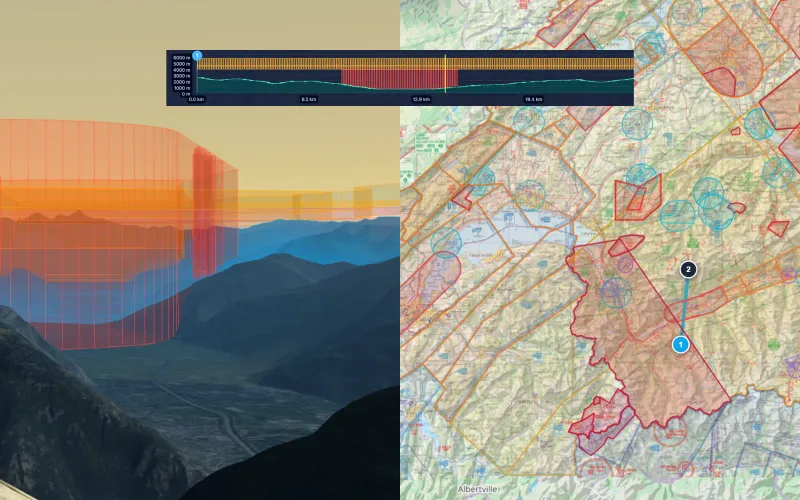
Airspace Route Analysis
Preview terrain and airspace limits along your planned route, then open vertical slices at any point to inspect stacked zones before takeoff.
FEATURE 14
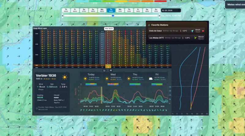
Smart Weather
Check wind, temperature, and conditions quickly with one-click favorite locations, altitude wind layers, and live stations + webcams.
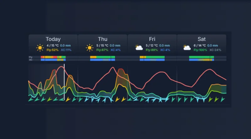
FEATURE 15
Flyability Score
Should you fly today? Get clear Can I Fly? and Can I do XC? guidance with daily potential and risk context.
A Lot for Free. Even More with Pro.
Most features are free, forever. No credit card required.
Free
Powerful tools, zero cost
- 3D flight visualization
- Flight analytics & detailed graphs
- Flight replay
- XC Route Planner with FAI triangles
- Airspace map & analysis
- Smart weather, wind layers & webcams
- Flyability score
- Sun synchronization
- Camera follow-mode
- Share your flights with friends
- Mobile compatible
- Save up to 2 flights
Monthly
Pay monthly, cancel anytime
- Everything in Free, plus:
- Unlimited flight collection
- Compare up to 10 flights at once
- Advanced colorization (AGL, vario, speed, glide)
- KK7 Thermal visualization
- Cinematic editor
- Video export
- Measuring tools
School Monthly
School manager workspace billed monthly
- School manager access
- Invite and manage up to 50 active students
- Active school students get full app access during their formation phase
- Overview of all student flights
- Create and manage formation events
- Manage student abonnement lifecycle
No hidden fees. Cancel anytime.
Ready to Get Started?
Join pilots worldwide analyzing their flights with XCviewer
Start Your Free TrialNo credit card required • Cancel anytime